The Georges River is considered one of the most severely flood-prone rivers in NSW. The narrow sandstone valley downstream of East Hills constricts the flow of water during floods, causing floodwaters upstream to rise. This is known as the 'bathtub' effect.
Some long-term residents in the area recall large floods in the river in 1956, 1969, 1975, 1976, 1978, 1986, and 1988. More recently, major flooding occurred in the Georges River catchment in February 2020 and again in March and July 2022. These were much smaller than floods in the late 1800s: the flood in 1873 was a 1 in 100-year event, during which water rose 10.5 metres and whole houses were washed away. However, given that more properties, residents, and infrastructure now occur along the river than ever, there is more potential for destruction and loss of lives.
Urban development will intensify floods
Since the 1980s, the Georges River catchment has been further developed. Future flooding will be exacerbated by the increased cover of hard urban surfaces, with assets along the river and in flood-prone areas vulnerable to flood damage. Fortunately, planning regulations, improving flood warning systems and flood mitigation projects work to reduce flood impact on the community. Climate change impacts are likely to exacerbate flooding risks with more severe weather events and rising sea levels.
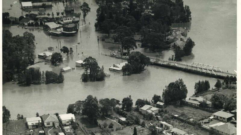
Large floods occurred in 1956, 1986 and in 2020
In February 1956, over 300 mm of rain fell across three days in the Georges River catchment, resulting in the flooding of 1000 homes and evacuation of 8000 people, including people being rescued from rooftops after fleeing from rapidly rising floodwaters.
In August 1986, over 320 mm of rain fell in 24 hours on one of the wettest days ever recorded in Sydney. The Georges River and Hawkesbury River flooded, resulting in 6 deaths and ten thousand homes being damaged, with the value of that damage estimated at $35,000,000. To provide some perspective on the intensity of rainfall, the average annual rainfall in the area is just over 870 mm (i.e., floods occurred owing to over a third of annual rainfall being delivered in single events). A 2001 estimate of the potential damage bill owing to a 1 in 100-year flood was $300,000,000.
After years of drier-than-average conditions, February 2020 saw approximately 320mm of rainfall in four days with 160mm recorded on February 10th at Bankstown Airport. The river rose rapidly with major flooding occurring along the river from Liverpool to Milperra. Minor flood levels were recorded at Picnic Point. Residents from suburbs including Warwick Farm, Lansvale, Georges Hall and Picnic Point were evacuated. The river peaked at approximately 8m at Liverpool weir. 2020 was the start of a wetter-than-average period for the region with three consecutive La Ninas resulting in numerous flooding events.
Despite significant rain falling in March 2021 with over 300mm falling over six days, the Georges River escaped any major flooding, with the nearby Hawkesbury-Nepean River system experiencing major flooding.
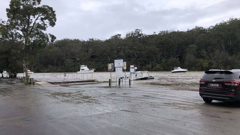
2022 had the wettest start to the year on record with average annual rainfall being exceeded by April. Two flooding events occurred in the space of a week in March with river heights peaking just below the major flood height of 7.2m at Liverpool Weir. The sodden catchment meant that further rain resulted in rapid river rises. A few months later at the start of July, another moderate flood occurred with the river reaching 7.1m at Liverpool Weir. This event hit the Woronora Valley in particular with 650mm of rain falling in the upper catchment resulting in significant damage to foreshore properties.
Floods in 2022 resulted in several hundred SES emergency callouts and over 70 rescues, 30 road closures during the event and an estimated $30 Million of damage to transport-related infrastructure in the Liverpool LGA alone.


Did you know?
The Georges River is severely flood-prone due to the narrow sandstone valley constricting floodwaters.
The last 1 in 20-year flood of the Georges River occurred in 2020 and caused severe damage.
The height of water for a probable maximum flood would be over double that reached in 2022.

Where is the floodplain?
The main floodplain of the Georges River occurs between Glenfield and East Hills, in Liverpool, Fairfield and Canterbury-Bankstown Local Government Areas. In that area, the river flows through low-lying areas with soft shale geology, whereas in other areas the river flows through deeper sandstone valleys. Those valleys act as a bottleneck during floods, with water backed up into low-lying areas.
Detention basins, levee banks, housing buybacks on floodplains, house-raising schemes and planning controls have been introduced to mitigate the impacts of future flooding of the Georges River, but these won’t prevent flooding. sanctus est Lorem ipsum dolor sit amet.
When will the Georges River flood again?
Floods are measured on a scale of the amount of time they are expected to reoccur, based on available records. The location of flooding is somewhat predictable, but the exact timing of flooding is not. Records indicate that floods occur in clusters between which there may be decade-long gaps before floods appear again. So, it is likely that on average a 1 in 20-year flood has a 5% chance of happening in any year. Given the clustered nature of floods, this does not mean we can rely on the next event coming exactly 20 years after the last. Floods in the 1980s and recent floods in 2020 and 2022 were both around 1 in 20-year events, which are considerably smaller than the largest floods that are likely to occur at some time (‘probable maximum flood’).
During flooding events, you can find emergency information, advice, and access to the latest river heights and rainfall observations and forecasts at:
When does flooding occur?
Flooding is unpredictable and can occur with many years between events or multiple times in a single year. Mainstream and overland flooding happens during and after heavy rainfall in a catchment.
How do I find out if my property will be subject to flooding?
View Georges River Flood Extent Map created by NSW SES.
Contact your local council and view the council's maps for flood-prone land.